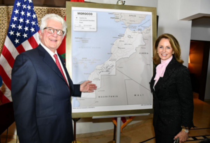
 The US government has officially adopted the undivided map of Morocco, including the Sahara southern provinces, American Ambassador in Rabat David Fischer said on Saturday.
Before Washington’s historical decision to recognize Morocco’s full sovereignty over the Sahara, the US government used a map of Morocco showing the southern provinces cut off from the rest of the country.
“I am delighted to present the map of the Kingdom of Morocco officially adopted by the US government,” said Fischer during a press briefing Saturday evening.
This map is the “tangible representation” of the outstanding proclamation made by President Donald Trump on December 10, which recognizes Morocco’s sovereignty over its Sahara, he said.
The US diplomat also underlined that he intends to offer this map as a present to King Mohammed VI, in recognition of the “bold” leadership of the Sovereign and his continuous and valuable support for the deep friendship between the United States and Morocco.
The US ambassador subsequently signed the full map of Morocco that the US government officially adopted.
The historic decision of the United States to recognize the full sovereignty of Morocco over its Sahara was announced Thursday Dec.10 during a telephone call between King Mohammed VI and the American President Donald Trump.
As the first result of this sovereign initiative of great importance, the United States decided to open a consulate in Dakhla, with an essentially economic vocation, in order to encourage American investments and to contribute to the economic and social development of the southern provinces to the benefit notably of the Sahara inhabitants.
In his proclamation, President Trump also said that Morocco’s serious and credible Autonomy Plan is the “only solution” to end the conflict and that an independent Sahrawi “state” in the Sahara is unrealistic.